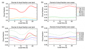
We have developed a method for retrieval of cloud optical thickness and cloud-top height from measurements of the two infrared bands of Himawari-8 (Sakai et al., 2019). The method is based on an empirical, simple model of brightness temperatures of Himawari-8 as functions of cloud optical thickness, cloud-top height, satellite zenith angle, surface temperature, and water vapor column amount. By acceleration of the calculation, full-disk data of Himawari-8 can be analyzed in real time. We have demonstrated that this method captures well the diurnal cycle of cloud amounts of different cloud types in the warm-pool region around Indonesia. This method yielded cloud amounts that agree quantitatively with those from a more rigorous, physics-based cloud retrieval method (Fig. 1). In future, it is expected that this method is applied to large-scale analysis of clouds, taking advantages of the high spatial and temporal resolutions of Himawari-8.
New publication:
Sakai, S., H. Iwabuchi, F. Zhang, Development of a Rapid Retrieval Method for Cloud Optical Thickness and Cloud-Top Height Using Himawari-8 Infrared Measurements. SOLA, 2019, Vol. 15, 57−61, doi:10.2151/sola.2019-012
Figure 1. One month-mean diurnal variations of cloud fraction of different cloud types (colors) classified by this method (solid line) and physics-based cloud retrieval (dashed line) for the region of 15˚S to 15˚N, 90˚E–160˚E using hourly data for January 2016. (a, b) High, middle and low-level clouds, (c, d) thick cloud (DC), Cirrostratus (Cs), and Cirrus (Ci) are shown. Results are shown for over (a, c) land and (b, d) ocean.

