
We have analyzed a typhoon in high temporal and spatial resolution by using the cloud properties from Japanese geostationary satellite Himawari-8 (Wang et al., 2019), whose retrieval method had been developed in our group. By dividing the high clouds into three COT categories: opaque high cloud (OHC), cirrostratus (Cs), and cirrus (Ci). Two alternatively appeared peaks in the cloud top height (CTH) within the storm central area, and their corresponding radially outward pulse processes are identified for a Super Typhoon case – Atsani (T1516).
Differences exist between these two pulse processes. The first pulse process (denoted by the black arrows) covers a 24-hour period, it starts at ~0500−0700 local solar time (LST), with a gradual radially outward transition from OHC to Cs, then ends in Ci at around 0400 LST. The second pulse (denoted by the gray arrows) lasts for half a day and limited within 1000 km from the storm center. When the first CTH pulse ends in the OHC, Cs, and Ci respectively, the cloud fractional coverage of these three cloud types and the outward expansion of large cloud optical thickness also reach maximum accordingly.
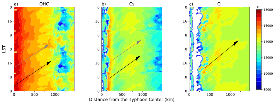
Figure 1. Diurnal pattern of the median-CTH, retrieved by ICAS with Himawari-8 observation from 0000 LST 17 August to 2400 LST 21 August. The daily average is shown in a 48-hour scale so that the complete pattern of the two pulse processes can be included. The black arrows indicate the morning-started diurnal pulse process, and the gray arrows indicate the afternoon-started semi-diurnal pulse process.
Publication
Wang, X., H. Iwabuchi, and N. Takahashi, 2019: Characteristics of diurnal pulses observed in Typhoon Atsani using retrieved cloud property data. SOLA, 15, 137−142, doi:10.2151/sola.2019-025.